Designated Properties

Please find below a list of Designated Heritage Properties and Districts in the Township of Muskoka Lakes.
Bala Bay Dock |
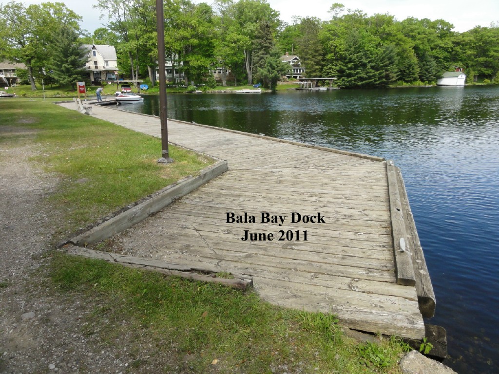
Designated on April 12, 2013 - By-law 2013-053 The Township Dock on Lake Muskoka (Township Dock), which is located on Portage Island in Bala, is a small public park less than one acre in size with public dock facilities. It is located east of Highway 169, and to the north of the adjacent North Bala Falls channel, to the east of the Canadian Pacific (CP) rail line and to the south of Mill Creek. The Township Dock is located in the same area as the “Steamship Wharf” that existed in this location and was linked by ramps to the 1907 CPR railway station. Steamship landings are recorded in Bala from the mid-1860's. The Township Dock represents a key link in the primary modes of transportation in the late 1800's and 1900's. This public waterfront property supports the traditional practice of arriving and departing Bala by water, making it “important in defining, maintaining or supporting the character of the area” as a water oriented community. Township Dock's historical and associative value lies in its relation to modern and traditional transportation, facilitating tourism and recreation in Muskoka for 150 years. The Township Dock site is used for picnicking, and swimming, and has been the site of the annual Bala Regatta for over 100 years. Following the construction of CP rail lines in 1907, the dock area, then known as “Steamboat Wharf”, was linked by ramp to the “Summer Station” on adjacent Canadian Pacific Railway property where the arrival of passenger rail service opened the area to tourists from across North America. Prior to the train, access had been by water and then by road, presently known as Highway 169. The wooden dock at the Township Dock, and its associated parkland provide open public access to the water and to the Bala town centre and more broadly, to the surrounding area of Muskoka. This dock is reminiscent of the earlier Steamship Wharf. There is potential to yield information or artifacts of the former ramps and docks on the property through marine or terrestrial archaeological fieldwork. The park area consists of a rough gravel drive, lawn, footpaths and is located next to the constructed railway embankment of the CP rail line. The park and dock is surrounded on three sides by water, Lake Muskoka, the Mill Stream, and the North Bala Falls channel and has an evolved shoreline as well as the manmade dock edge. Vehicular access to the property from the north is by way on a bridge over the Mill Creek from Gordon Street on the adjacent property. The site's contextual value lies in its open views to Lake Muskoka, and to nearby forest and cottages, as well as its provision of ongoing connection and transfer points between watercraft and the Bala town centre. It is a key part of a larger cultural heritage landscape of Bala. The view from the dock and/or flat grassy area looking south-west to the CP rail line bridge relates to rail transportation, the view of the portage landing relates to water transportation and tourism themes, both important themes in the cultural landscape of Bala. Even though there is no longer passenger rail service, passing freight trains continue the visual and acoustical association between water and rail transport. |
Bala Heritage Conservation District |
|
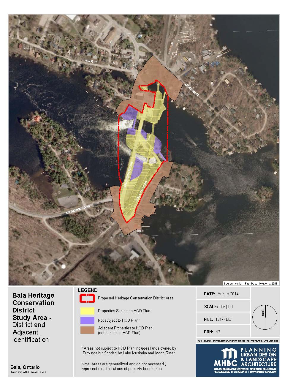
The combination of built features, streetscape, open space and natural landscape elements within the study area is the result of human intervention on the Muskoka landscape. Elements within the study area are physical remnants or reminders of the various developments and themes in Bala's history, including aboriginal use, early settlement, the timber industry, tourism and seasonal residency, and transportation. There are a relatively small number of built features in the study area, and the types are limited to vernacular structures and bridges. The built features and streetscape/landscape/open space character of the area is interrelated to the natural environment, having been shaped by it, and also by having shaped it. Views of Muskoka Lake, the Moon River, the North and South Falls, rocky shorelines and vegetation are available from several locations within the study area. The character of the area is representative of the Muskoka Area, but also unique to the community of Bala in the precise location and configuration of water, land, and human-made elements. The character of the study area has already been recognized for having cultural heritage value or interest. Four properties within the study area have been designated under Part IV of the Ontario Heritage Act (Portage Landing [Burgess Island] on the Moon River, the Shield Parking Lot, the Township Dock on Lake Muskoka and the Burgess Memorial Church) for their physical or design values, historical or associative values, and contextual values. The twin stem Silver Maple Tree on Burgess Island and the White Pine grove in Margaret Burgess Park have been nominated for designation as Heritage Trees under Part IV of the Ontario Heritage Act. Physical elements of the study area have changed and will continue to change over time. Many built resources from Bala's early history have been removed or modified, but have been commemorated and continue to be valued by the community. The associative values of the study area, experienced by views to the lake, river and falls are an important component in maintaining the character of Bala. Human desire to experience the landscape (both natural and human-made) has been well articulated since the Romantic era, where elements of the ‘sublime' and ‘picturesque' in the landscape captivated the human spirit, and provided outlets for contemplation, spirituality, recreation and relaxation. These values became translated to the Canadian ‘wilderness' in the 19th and 20th centuries, where the experience of nature and naturalized features was valued for its beauty and restorative power, and the northern landscape became a symbolic interpretation of the Canadian frontier. These elements contributed to the historical development of Bala as a tourist and recreational location, and continue to characterize the study area for present-day residents and visitors. |
Bala's Museum with Memories of Lucy Maude Montgomery |
|
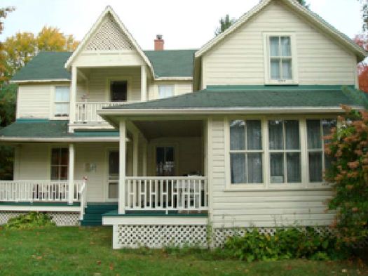
The property's cultural heritage value lies in its service for many years as a tourist home and it's subsequent restoration and adaptation to a museum. Historical and associative value also reside in the property's association with Canadian author Lucy Maud Montgomery, who wrote numerous short stories, poems and more than twenty novels including Anne of Green Gables. On October 19, 1909, Fanny Pike obtained title to the property, purchasing it for $175.00 from Katherine W. Carr, a daughter of Thomas Burgess who founded Bala. Fanny and her husband, Charles Pike, had recently come to the area from England likely because Fanny's brother lived in Bala. Charles worked as a trackwalker for the railway that had reached Bala in 1907. Charles built the Pike home, which originally had a single room on the main floor and an upper sleeping loft. By 1915, the Pikes had expanded the residence to its current footprint and were taking in guests at what was called “Tree Lawn House.” Fanny Pike also assisted Bala's doctor as a midwife. In 1922, Lucy Maud Montgomery vacationed with her husband the Reverend Ewan Macdonald and two sons at Roselawn Lodge on what is now River Street. The dining room was not staffed at Roselawn that summer, so the family ate all meals at Tree Lawn. Montgomery's diary describes Fanny Pike and Tree Lawn, as well as many of the sights and sounds of Bala. As recorded in diary entries, that two-week holiday provided the inspiration and setting for Montgomery's novel The Blue Castle, published in 1926. It is the only one of her novels not set on Prince Edward Island. Since 1992, this building has served as a museum with many exhibits featuring L. M. Montgomery and other aspects of Bala's history. The interior has been restored to the period of Montgomery's visit to Bala. Exterior repairs have respected the integrity of materials and finishes and many replaced features were salvaged from local buildings to maintain authenticity to the time period. The Museum regularly hosts cultural events. Visitors from across Canada, the United States, Europe and Asia have enjoyed this cultural heritage resource while gaining insight into the personal life of one of Canada's most widely translated authors. |
Bala Precambrian Shield Parking Lot |
|
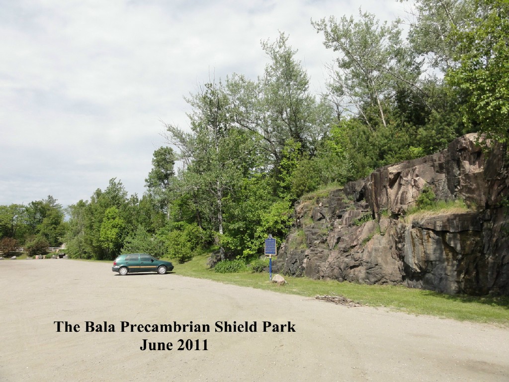
Shield Parking Lot, east of Highway 169 in Bala, is the wedge-shaped property bounded on the north by the Ministry of Transportation Property next to the channel of South Bala Falls, by Highway 169 on the west, and by the Canadian Pacific (CP) property on the east. It is part of Lot 33, Concession VII of the former Township of Wood, now in the Township of Muskoka Lakes. Along the eastern boundary lies a large quarry face exposed during highway construction of the 1960's Shield Parking Lot contains the impact of 1960's Ontario government highway construction program that resulted in both dramatic physical change creating a new public space, and a resultant increase in the tourist economy of Bala following improved road access. The original outcrop that formed the shoreline of the Moon River was larger than the current quarry face. The boundary between the municipal property and Crown land to the north approximates the edge of the original outcrop. Shield Parking Lot‘s physical value is as a representative example of the transformation of a natural Precambrian rock outcrop by highway construction methods of the 1960‘s such as blasting, crushing and fill. Drill holes where dynamite was inserted are evident on the resulting quarry face. Originally a staging area for the construction process to re-route Highway 169, the flat sand and gravel surface is representative of the changes in the town of Bala that occurred during the highway construction, the result of the removal of material from the rock face, crushed and used elsewhere as fill. The quarry face is a large and representative example of the Precambrian Shield, and exhibits the folding and layering patterns of pink gneiss and black amphibolite characteristic of the Muskoka area. Along the quarry face formation are various species of native plants and trees including birches, white pines, sugar maples, red oaks, trembling aspens, and sumacs. There are also various wildflowers, including daisies and wild daylilies, growing along the base of the rock quarry face. The historical value lies in the effect on the townscape and the tourist economy, shifting to primarily automobile access from a mix of road, rail and water transport. The site has associative value linked with the highway construction, the relation to the larger Precambrian shield, and as a site for community events. The quarry face is commemorated as a large and representative example of the Precambrian Shield of Ontario in a plaque installed in 1966, shortly after the highway opened in July, 1965, by the Archaeological and Historic Sites Board of Ontario (AHSBO). The plaque text explains how the shield impeded agriculture in the region, but led to the development of mining, lumbering and tourism as key industries of the province, and also notes the rock is among the oldest of the earth's crust and occupies two thirds of the surface of Ontario. The CP rail line, located adjacent to the site along the top of the quarry face, makes a visual and acoustical association between the Shield and industrial and tourism development, two key facets of the Muskoka economy, also themes of the cultural landscape of Bala This Shield Parking Lot has contextual value as a stopping and vantage point representative of the natural beauty of Muskoka, the Precambrian Shield quarry face, and its associated lakes, rivers, trees and wildlife. The quarry face is a landmark in the community, marking the entrance to Bala from Highway 38, and contributes to a strong sense of place. The parking lot has an important view to the Moon River across Highway 169. The site also connects to viewing places on the adjacent Provincial property that provide views of the South Bala Falls, the designated building, formerly the Burgess Church across the south channel, and sounds of adjacent waters. Located central to Bala, the public park including parking lot facilitates touring Bala's other scenic lookouts, including those over Lake Muskoka and the Moon River. |
Burgess Memorial Church |
|
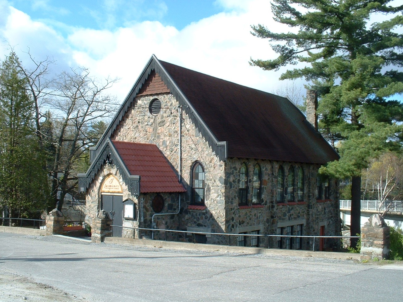
Early in 2002, the Township of Muskoka Lakes designated the Burgess Memorial Church in Bala as a heritage property under the Ontario Heritage Act. Research by Municipal Heritage Committee showed this property should be designated on the basis of its architectural/ historical importance. In brief, our reasons for designation are as follows: The Burgess Memorial Church, built in 1926 on Bala Falls Road, is recommended for designation for architectural reasons as it is a beautiful example of a simple Gothic church built in Muskoka in the early 20th century. Erik Skat-Petersen, Dick Hamill, Knud Skat-Petersen, Aage Skat-Petersen and Gordon Ing, whose initials are carved in the mortar on the east side, all played an intricate part in building the church. Elements of the Gothic style are evident in the pointed arch-shaped windows, gable roof, and decorative bargeboard. Of particular interest is the fact that local and seasonal residents were encouraged to bring stones for the construction. As a result, the uncoursed fieldstone exterior includes rocks of all shapes and sizes from as far away as the United States. The six-over-six sash windows in the lower level are surmounted with concrete hood mould or dripstone. The yellow pebble glass in the nave windows is original. Round windows in the entrance and terra cotta roof tiles on the entrance and on the windowsills give the church a picturesque charm befitting its prominent location on a small island in the Moon River, next to the Bala Falls. The church is named after the founder of Bala, Thomas W. Burgess, who arrived in the area in 1868. It owes its existence to Presbyterians who did not accept the 1925 union of the Methodist and Presbyterian faiths and the designation of Bala's original Presbyterian church as a United Church. The Burgess Memorial Church was built on land owned by the Thomas Burgess estate. In August 1964, the board of the Presbyterian Church sold the building to Shirley and Thomas Linke. The church was used as a Baptist Church during the Linkes' ownership. Known as the Stone Church by many, the Burgess Memorial Church is a prominent landmark of historical significance. In the summer of 2000 the church was decommissioned and was rezoned for commercial use in October, 2000. The retention of the existing exterior features is recommended to preserve the character of Bala's streetscape. |
Glen Orchard Schoolhouse |
|
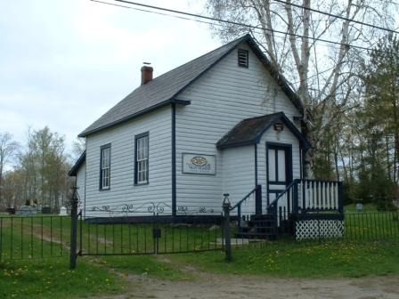
Early in 2009 the Township of Muskoka Lakes designated the 1890 Glen Orchard Schoolhouse and Cemetery as a heritage property under the Ontario Heritage Act. Research by a Heritage Consultant showed this property should be designated on the basis of its historical, design, and associative importance. In brief, our reasons for designation are as follows: The frame building was built in 1890 and is an excellent and well-preserved example of a one-room rural school which was a prominent institution and played a central role in community life. Later, the building served the community as a library and home to the Glen Orchard Women's Institute. |
Lake Joseph Community Church |
|
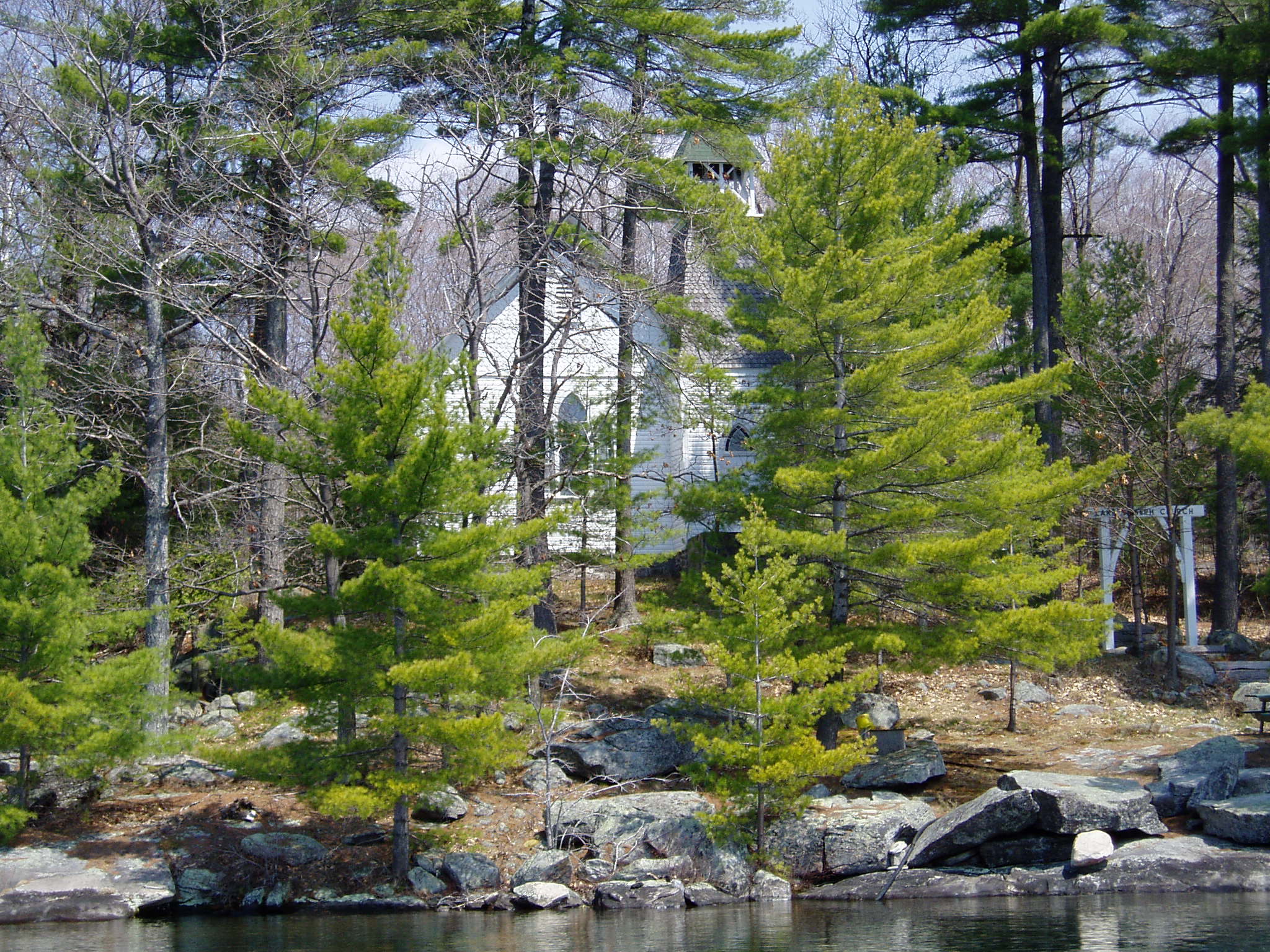
In June of 2003 the Township of Muskoka Lakes designated the The Lake Joseph Community Church in Minett as a heritage property under the Ontario Heritage Act. Research by Municipal Heritage Committee showed this property should be designated on the basis of its architectural/ historical importance. In brief, our reasons for designation are as follows: In September of 1902, permanent and summer residents purchased property for a church on Lake Joseph. The waterfront site, part of lot 17, Concession 8 in Medora Township, is at the mouth of Cumberland Bay. The Mackenzie brothers of Staney Brae designed and built the church in time for the gala opening on August 9th, 1903. Members of the congregation were both permanent residents and cottagers, from Pittsburgh, Poughkeepsie, New York, Hamilton, Toronto and Montreal. It has been used every summer for services with the exception of 1933 and 1934. The overall style of the church is straightforward and unornamented Ontario vernacular. The steeply pitched roof is complemented by a simple bell tower clad in scalloped cedar shakes. The original, leaded, pointed arch windows line each side of the double aisle church. The original shape and white colour of the building have been retained. One of the most notable architectural features of the building is the interior with its original high ceiling and basswood panelling in a simple medallion pattern. The Lake Joseph Community Church continues to enhance a strong sense of the multi-generational lakeside community by providing interdenominational Sunday services each summer. The church continues to be a landmark on Lake Joseph. |
Portage Landing on the Moon River |
|
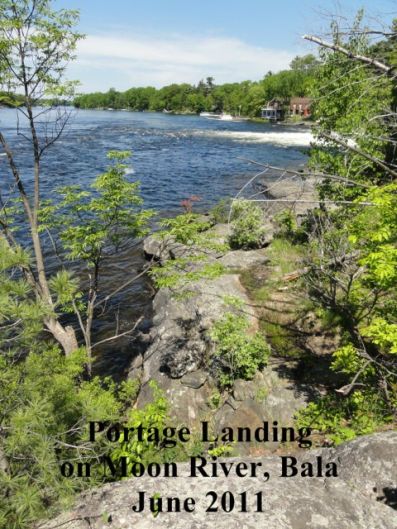
Portage Landing on Moon River is a portage site and rest area on the island between the north and south channels of the Bala Falls, in Bala, west of Highway 169, at the shore of the Moon River and next to Crown property abutting the North Bala Falls. is surrounded by water on two sides, the channel of South Bala Falls and the Moon River and includes a steep embankment to the east to the edge of Highway 169. Portage Landing on Moon River is the traditional portage used by First Nations people and later by tourists, YMCA campers and cottagers. It defines and supports the character of Bala as a water based summer resort and the vista looking westward from the property is breathtaking. The property's cultural value and interest lies in the features which support its historic and continuous use as a portage landing and scenic outlook point; the natural shoreline, Precambrian Shield outcroppings, the flat rock resting area at the water's edge and natural footpaths, native trees, grasses, wildflowers, the slight elevation above water level along with the absence of artificial lighting and buildings enhance the scenic experience. Portage Landing on Moon River has historical and associative value for the Bala community and nearby Mohawk natives as part of the traditional portage for more than 100 years. It is found in early and contemporary postcard views and tourist accounts of the area, The eddying of the water of both falls pushes watercraft towards this natural landing point. As part of a long established canoe route from the Musquosh and Moon Rivers to Lake Muskoka, the portage was passed and identified by the explorer/cartographer David Thompson as part of his mapping of the Muskoka region starting in 1830, and is also associated with the Mohawk relocation from Oka Quebec to the Gibson Reserve, now Wahta Territory, for religious reasons, in October, 1881 Portage Landing on Moon River's contextual value lies in its relation to the important theme associated with the broader cultural landscape of Bala, tourism, and to a lesser degree transportation. In addition to its portage function, the property has public park functions including scenic enjoyment, picnicking, and photography. The historical split trunk maple tree (Native Maker Tree) on the adjacent property can be seen from the landing, and appears in many historic photos. Portage Landing on Moon River connects to the shortest portage route across lands informally named both Portage Island and Burgess Island, that is across Crown Land up the side of the concrete abutment at the North Bala Falls, and across Highway 169, to the portage landings on Lake Muskoka. The portage and scenic experience is enhanced by the sound and spray from cascading waters over both channels of the Bala Falls, as well as unobstructed views to and from the Moon River, across the north and south channels of the Bala Falls, and towards Margaret Burgess Park. |
Township of Muskoka Lakes Municipal Office |
|
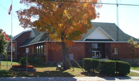
Early in 2009 the Township of Muskoka Lakes designated the former Port Carling Schoolhouse as a heritage property under the Ontario Heritage Act. Research by a Heritage Consultant showed this property should be designated on the basis of its historical, associative, contextual, and design values. In brief, our reasons for designation are as follows: The property also holds associative value as Ontario's 27th Lieutenant-Governor, James K. Bartleman, was a student at the school. During his term from 2002-2007, he championed various causes including literacy and education, frequently recognizing the formative influence of the Port Carling School. The property also has design value due to adaptive re-use of the former school as municipal offices beginning in 1971. The recent additions add design value as they embody respect for contemporary guiding principles of conservation of historic properties. Respect for original location, materials, fabric and legibility have been maintained. The property also has contextual value as it remains a landmark in the community, housing the Township's Council Chambers and core municipal services in modernized interior facilities. |
Windermere Post Office and General Store |
|
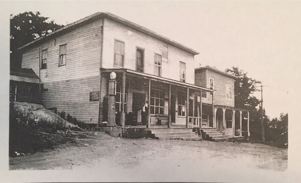
Developed in the late 19th century, the property has design value that provides early examples of the architectural style in the Village of Windermere and demonstrates the rare and early specimens of construction styles, materials and methods used in original structures of the early tourism period of Windermere. The former Post Office and General Store were constructed in 1896 and recognized as being among the oldest surviving wood structures in the area. The Benjamin Taylor cottage was constructed between 1911 and 1914 and was occupied by early settlers of Windermere. The wooden ice house building is one of the last cold-storage buildings left standing in Muskoka and the stone storage building is a unique example of a structure built of local material, including field stone and timber gable framing. The property is associated with the early families who settled in Windermere, particularly the Fife, Aitken and Taylor families, as well as the families' commercial interests and role in the growth of Windermere as a lakeside community. The property also has contextual value as it fronts on Windermere Road across from the Windermere House resort. The buildings on the property, viewed together with adjacent Windermere House are a unified complex and form a unique streetscape that dates to the early period of tourist and cottage development, and convey a strong sense of time and place. Together these buildings maintain and support the summer resort character of the area, especially when approached from Lake Rosseau. |
Contact Us

 Approved on October 17, 2014 - By-law 2014-131
 Designated on April 12, 2013 - By-law 2013-051
 Designated on April 12, 2013 - By-law 2013-054
 Designated on March 11, 2002 - By-law 2002-37
 Designated on April 7, 2009 - By-law 2009-53
 Designated on June 16, 2003 - By-law 2003-94
 Designated on April 12, 2013 - By-law 2013-052
 Designated on April 7, 2009 - By-law 2009-52
 Approved on March 15, 2019 - By-law 2019-27
 Subscribe to this Page